Why are field and laboratory measurements important in remote sensing?
There exist lots of satellites, drones, and other instruments, all of which deliver huge amounts of data, but these data get their full meaning only through use of reference measurements.

Remote sensing can help us to monitor the environment and utilize the natural resources in sustainable ways. A variety of interpretation algorithms exist that aim at deducing relevant information out of the remote sensing data. It is easy to get an impression that everything is nice and automatic, and the machines do the work for us. Of course, remote sensing can reduce the amount of field work (this is, after all, one of the main purposes of using it), but still it often gets forgotten that almost no application works without some reference data. To a computer, a satellite image is just a collection of numbers. Someone needs to give it the meaning and to verify that the interpretation made of the data is correct.
Therefore, having some reference data (collected in situ or in the lab) is almost unavoidable in any remote sensing application. There are two main interpretation approaches for remote sensing data: empirical (also called statistical or machine learning) and physically-based. Let’s imagine that we want to map the properties of a forest, such as stem volume or carbon stored in the trees. In the empirical approach, we identify patches of forest and then study how the remotely sensed signal depends on the forests’ properties, and vice versa. In a physically-based approach, we would get to know these dependencies by running simulation models on artificial forests, but we still need some information on what the realistic values for the model parameters are. This information is obtained through measurements.
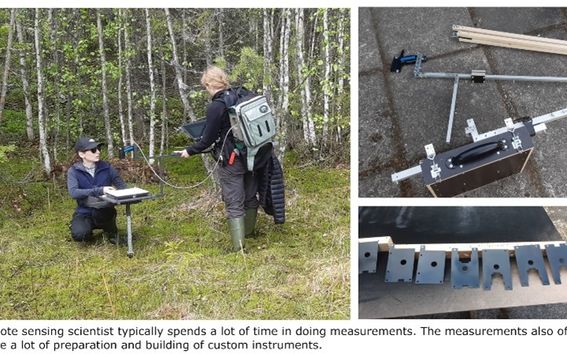
As a concrete example, the scientists at Aalto University have been developing a simple yet accurate computer simulation model that can be used for interpreting remote sensing data from forests. During the last three years, the project has involved several weeks of field work in each summer. While practical measurements outdoors in the forest are typically as fun as they sound like, there are many challenges and uncertainties related to them. Things like weather changing unexpectedly just as you are getting ready to measure, or a swarm of mosquitos biting on your hands while you should be holding the sensor steady, or just generally handling all the delicate (and often expensive) equipment in the wild can be a challenge to anyone. On the other hand, practical measurements are often a collaborative work done in teams and learning this ‘craftmanship’ is important and valued skill for almost every remote sensing scientist. As a side effect, you obtain lots of fresh air and get to travel in beautiful and interesting places.
About the author: Aarne Hovi is a researcher in the Remote Sensing Research Team at Aalto University.
Show other posts from this blog

#30DayMapChallenge: 30 days – 30 maps
Make the map speak for you!
Länsi-Antarktis on mannerjäätiköiden heikko kohta
Läntisen Etelämantereen jäätiköt ovat avainasemassa siinä, kuinka nopeasti merenpinta alkaa nousta ilmaston lämmetessä.
Development of Finnish agricultural parcel structure 2010-2020: a spatial analysis
Hermanni Hentunen analyzes the temporal development of parcel structure in Finland between the years 2010 and 2020.