Development of Finnish agricultural parcel structure 2010-2020: a spatial analysis
Farming is, if something, a land-intensive process. To increase production in a factory, one needs to build more productive machines. But increasing yields in faming is not that easy. Sure, some measures can be taken enhance the soil, for example. But after a certain point, there is not much one can do. To increase production, more land is needed.
In the 1960s there were more than 300 000 farms in Finland. In 2021, that number was 44 700. As the number of farms has decreased, the average size of a farm has increased, reaching 51 hectares in 2021. The need for land should be satisfied, right?
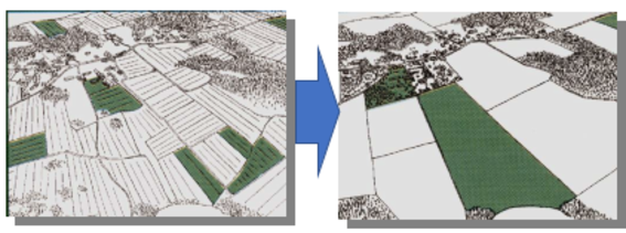
The economies of scale are lost, however, as the increase comes through small, dispersed parcels. Small parcels are inefficient to farm, and due to the size, new technologies, such as automated machinery cannot be used on them. Parcels are also often discontinuous and far apart. This leads to more time spent driving to the fields, higher fuel consumption as well as having implications on road safety.

Land consolidation is a land management tool, in which the dispersed parcels are combined to larger units closer to the farmsteads to increase production and profitability. The new parcel structure is planned in cooperation with the landowners, taking into consideration their needs and wishes. In Finland, land consolidations are carried out by the National Land Survey of Finland (NLS). To focus the projects in areas where they are most needed, various tools and measures hav been created by the NLS as well as its’ subdivision, Finnish Geospatial Research Centre FGI.
FGI has, for example, created farming parcels from the Finnish parcel registry. These farming parcel combine into larger units those fields that are owned or rented by the same farmer and are in close proximity to each other. They depict more accurately the actual parcel structure. Also, distances and travel times to every such parcel from the homestead was calculated, using National Terrain Database road vectors as the network. Every road class was given a speed limit based on how fast a tractor can drive on them.

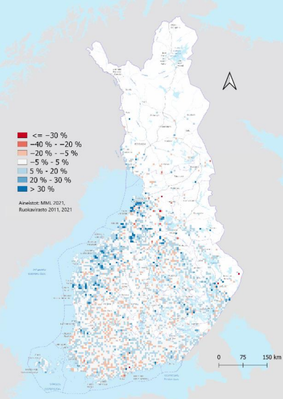
Information on temporal change is also vital, for both planning future land consolidations as well as examining the effects of previous ones. During the 10-year period between 2010 and 2020, the average farming parcel size increased by 4,6 %, or 0,14 hectares, to 3,18 ha. The median size grew by 0,05 ha to 1,79 ha. When examining the spatial distribution of growth, it can be seen that the growth is quite centralized, especially to the Ostrobothnian provinces. The same provinces are the central areas for land consolidations which is not a coincident. In areas where land consolidations have been carried out during the 10 year period, the average parcel size had grown by 27 %.
The average distance from a homestead to a parcel had grown by 19 %, and the travel time by 17 %. This shows that new parcels acquired by farmers are so far away from the farm itself that bigger and faster roads can be used. This has both environmental and safety effects.. The growth indicated nearly a fifth more of driving, burning fuel and time not spent on actual production, just in 10 years. In land consolidation areas, the distance grew only by 11 %, proving again that they can help to solve the problems caused by a fragmented parcel structure.
About the writer: Hermanni Hentunen wrote his master’s thesis in geoinformatics on the temporal development of parcel structure in Finland between the years 2010 and 2020. The changes were determined using various spatial analytics methods. He is currently working with land consolidations in the National Land Survey of Finland. Results of the thesis are used by the NLS in land consolidation project planning, implementation, and communications. The thesis (in Finnish) is available in Aaltodoc.
Show other posts from this blog

#30DayMapChallenge: 30 days – 30 maps
Make the map speak for you!
Länsi-Antarktis on mannerjäätiköiden heikko kohta
Läntisen Etelämantereen jäätiköt ovat avainasemassa siinä, kuinka nopeasti merenpinta alkaa nousta ilmaston lämmetessä.
What is the value of earth observation data?
With socioeconomic impact assessment it is possible to specify and quantify the impact that earth observation data has on our society.