What is the value of earth observation data?
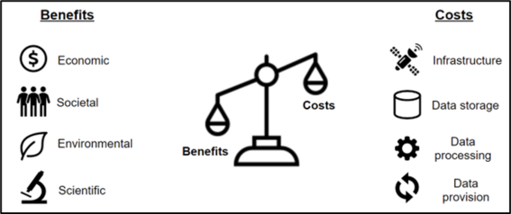
Earth observation data brings immense benefits to society, as they enable countless innovative solutions for monitoring, understanding and predicting changes in our environment. The usage of this spatial data for better decision making brings significant societal, economic, environmental and scientific benefits. With socioeconomic impact assessment it is possible to specify and quantify the impact that earth observation data has on our society.

Socioeconomic impact assessment is a collection of methods that are used to measure and present the impacts or value that accumulates in the society resulting from an action. These methods provide an objective basis to evaluate the impacts of earth observation data. The results of the assessment work can be used to communicate the value of earth observation data to key stakeholders, to defend earth observation research budgets against competing priorities and to justify the investments made into projects and programs.
The range of socioeconomic impact analysis methods that have been used to assess earth observation data and services is wide, and they all have their advantages and considerations. Some assessment methods focus on determining the monetary value of the use of the data compared to the costs of providing it, while other methods emphasize how value flows to different actors in society.

Impact assessment methods are typically interested in determining the monetary value of the analyzed data, product or service. Getting an estimate of the economic benefits (i.e. how many euros the use of the data is worth), compared to how much was invested in producing it, is often interesting to investors and stakeholders. However, it can be difficult, even controversial, to estimate the monetary value of some benefits. For example, what could be the value of the increased feeling of safety among people?
Some socioeconomic impact assessment methods have also been used to identify how the benefits of a service could be improved. In these cases, the user groups of the service and how they use and experience the service are analyzed. For this end, it is possible to use web traffic analysis methods to identify the user groups that are accessing the data and what parts of the data are most interesting to users. To make the data or the service as beneficial as possible the needs of the end-users as well as the accessibility and usability of the data should be considered.
When browsing impact analysis studies assessing earth observation services, it becomes evident that the benefits from using earth observation data are immense and that further investments to the industry are justified. For example, EARSC report (2015) showed that using Sentinel data for observing the movement of ice sheets can save up to 17.5 million euros annually. Before using radar satellite imagery for monitoring the ice sheets, helicopters on board of the icebreakers were used for guidance. Using satellite data, the routes can be optimized under any weather conditions as well as more efficiently, saving both time and fuel.
It is important to communicate the benefits of spatial data, as the impacts from earth observation projects are not always evident to decision-makers. Moreover, the investments often need to compete against other priorities. The results of a socioeconomic impact assessment can be used to justify that services that are developed during a project need maintenance and further investments for the full potential of the benefits to materialize. On the other hand, the results of an impact assessment can also help in developing a service to give greater benefits to its users by identifying the services strengths and weaknesses.
About the author: Isabel Donner wrote her master’s thesis comparing socioeconomic impact analysis methods that have been used for assessing earth observation data. The study aims to determine the most suitable tools for the assessment of benefits from the usage of earth observation data and services in the Arctic. The motivation behind the work is that actors in the Arctic region are going to be more dependent on earth observation services in the future, as the Arctic environment is changing rapidly due to climate change. The thesis is available at Aaltodoc.
Show other posts from this blog

#30DayMapChallenge: 30 days – 30 maps
Make the map speak for you!
Länsi-Antarktis on mannerjäätiköiden heikko kohta
Läntisen Etelämantereen jäätiköt ovat avainasemassa siinä, kuinka nopeasti merenpinta alkaa nousta ilmaston lämmetessä.
Development of Finnish agricultural parcel structure 2010-2020: a spatial analysis
Hermanni Hentunen analyzes the temporal development of parcel structure in Finland between the years 2010 and 2020.